Thursday, July 31, 2014

Day 52: Brooks Lake Campground to Rocky Meadow (Mile 1942)

We started our day with a delicious breakfast at Mom's, a popular Dubois breakfast cafe, hands down the best breakfast on the trail thus far. Having just learned that we would need a permit and campsite reservations to hike through Yellowstone, I called the permit office and was relieved to be able to reserve workable sites, sharing with other CDT hikers one night due to limited availability of sites as we near Old Faithful. Permit number in hand, we returned to the trailhead at Brooks Lake. 

The sun lit the massive cliffs above the lake. We followed the trail through flower-filled meadows on the west side of the lake, then climbed gently to Upper Brooks Lake.  A bald eagle soared over Upper Brooks Lake, then disappeared into the trees beneath the cliffs. 

Towering thunderheads began piling up by lunch, and shortly after we left Cub Creek the skies opened and began to pour. Rain turned to hail as we sheltered in a small grove of pines to cover our packs and put on rain gear. 

Ahead up the trail, Blue Suit, a southbound CDT hiker in a distinctive blue jumpsuit, sheltered underneath another grove of trees. We stopped to talk for awhile. Blue Suit warned us about an upcoming river crossing, the South Buffalo Fork of the Snake River. 

Although an early season CDT hiker, Morrisey, had described the river as unfordable, we had heard that the water had subsided in the intervening days and knew that several other hikers had gotten through. Now Blue Suit eyed Sierra warily while he described cold, deep, fast moving water.

Several wet, rainy miles later, we reached the river. I started across first, my legs quickly becoming numb in the frigid, thigh-deep water. Leaning into the current, I slowly worked my way across the fast moving water, taking Blue Suit's advice to work my way slightly downstream as I moved across to stay out of the deepest water. Once across, I dropped my pack and went back in the river to shadow Sierra, who was already working her way across.  She didn't need my help, and we were soon both safely across. 

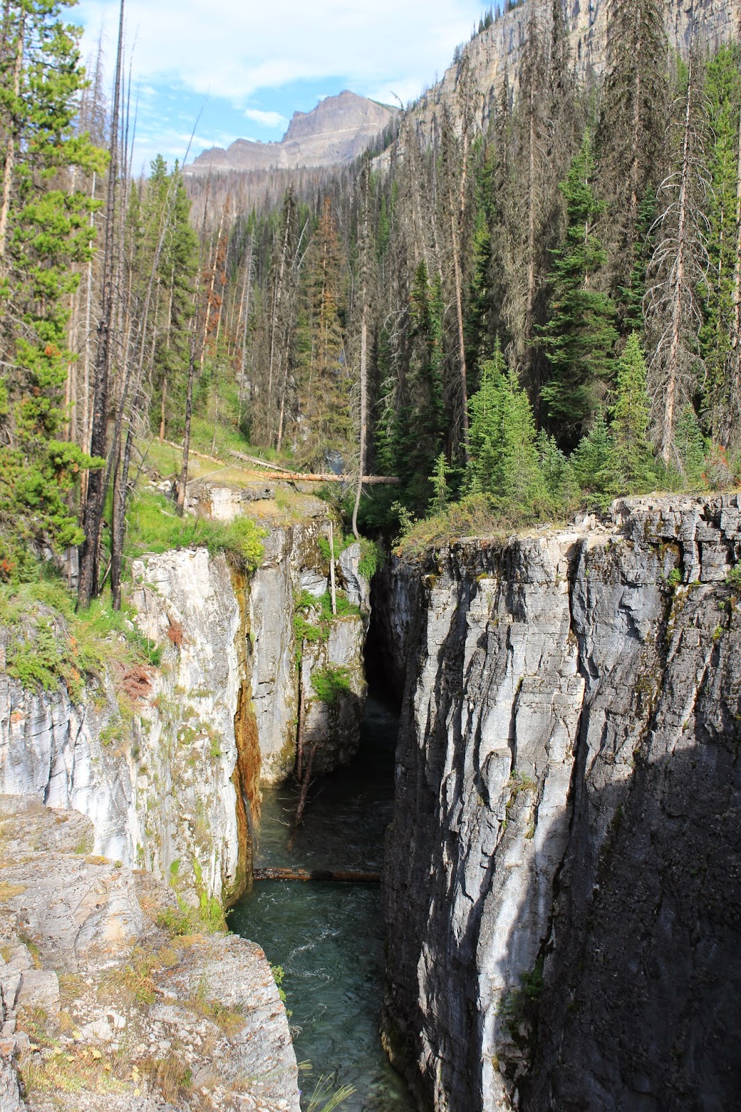
We had heard that South Fork Falls is a fantastic side trip, just under a mile and a half round trip. We were not disappointed. Upstream from our crossing the South Fork drops down a steep waterfall, then winds its way through a narrow, deep chasm or carved over time by the torrents of water raging down the river. In places the slot canyon is so narrow hikers have actually jumped across, although missing the bank on the other side of the steep cliff would mean falling over a hundred feet to certain death. Predictably, Sierra wanted to jump to the other side to explore a tiny crack on the other side that appeared to lead down to the floor of the canyon. 

Instead we headed back to the trail and hiked on. Sierra discovered a seemingly abandoned baby pheasant in the grass next to the trail. Thankfully the mother pheasant was nearby.  The baby pushed its way through a forest of grass and reunited with her. 

We passed through a large burn area, fireweed and other wildflowers brightening the otherwise dismal landscape. Finally we found a damp camp in a small meadow next to a cluster of living trees. We found a high branch and hung our food safely out of the reach of the black bears and grizzlies that populate this area. 


Wednesday, July 30, 2014

Day 51: Forest Service Road to Brooks Lake Campground (Dubois)

Large clumps of mud clung to the bottom of our shoes, each one weighing as much as a brick. Lugging our heavy shoes up the sodden trail, we collected a new layer of mud with every step. 

We continued following forest service roads until we reached Highway 287.  No markers indicated where the trail continued on the other side, but with the solar charger we had just enough power to check our position using GPS, following the trail along a winter snowmobiling route. 

My father met us at the Brooks Lake Campground and took us into the small town of Dubois. In addition to the usual town chores we saw the world's largest jackalope and visited the National Bighorn Sheep Interpretive Center. After a delicious pizza at Paya, we shared some ice cream and headed for bed. 


Tuesday, July 29, 2014

Day 50: A Day Without GPS

Dark gray clouds blanketed the sky. Moments after we started hiking, the rain began with a steady drizzle that would continue all day. 

CDT markers, rock cairns, and ribbons are the siren song of the CDT, luring unsuspecting hikers off established trails onto the unmarked official CDT route.  We dutifully followed, relying heavily on GPS to stay on track. Shoes squishing, rain soaked pants clinging to our legs, we slowly pushed our way through waist high willow, sage, and grasses, scrambled over scorched logs and branches, teetered precariously on thick mud sole platforms. 

Loud screeches, shrieks, and caws filled our ears. The warning cries of elk. Moments later a large herd thundered across the trail ahead. 

Unfortunately, the GPS gave out before noon, abruptly powering down when the battery indicator read 20%. With no hope of sunlight on such a dreary day, our backup power source, a solar charger, was useless, leaving us to blindly follow sporadic CDT markers and other obscure trail markers. 

Sierra slipped on a mossy rock and toppled over backward into the creek, soaking herself and dunking her pack. Thankfully her down sleeping bag was safely stowed in a waterproof cuben fiber dry bag lined with a plastic trash bag so it did not get wet. 

After meandering through the forest on barely discernible paths all afternoon, the trail joined a series of forest service roads. We reached a clear cut section and all trail markers disappeared, presumably cut down with the trees.  We camped in the trees just beyond the logging operations in a wet, muddy camp next to the trail.


Monday, July 28, 2014

Day 49: Green River Lake Campground to Trailside Camp (Mile 1,892)

With frequent backward glances back up the Green River to the breathtaking Wind River Range, we hiked on into the rolling hills. Several varieties of bright yellow sunflowers blanketed the hillside, with a sprinkling of lupine, fireweed, wild roses, and other colorful wildflowers. We passed through aspen and pine forests, crossed the Roaring Fork River, then climbed steeply to Gunsight Pass. 

Dark, towering thunderheads greeted us in the other side of the pass. We watched the rain on a nearby ridge, then descended. 

"Mooooooooo!  Moooooooo!"  Loud cries alerted us to cattle grazing in the woods. We encountered several herds, including many cows, calves, and at least one bull as we followed the trail through the woods and into open grazing land. 

Climbing back into the trees, we passed a series of mosquito infested swamps. Plagued by mosquitoes and biting flies alike, we hurried past as quickly as possible. Despite liberal application of insect repellent, both the mosquitoes and biting flies demonstrated an impressive instinct for choosing places to bite that are difficult to protect, such as the thin strip of flesh between my sunglasses and hat. 

Late in the afternoon we spotted a large herd of elk grazing on the ridge. The elk loped away as we approached. 

Looking west, the Grand Tetons and Mount Moran rose up to the clouds off in the distance. The clouds continued to gather as we found a camp in the trees near Bull Moose Creek.


Sunday, July 27, 2014

Day 48: Upper Jean Lake to Green River Lake Campground

A thin layer of ice covered the icy pools of snowmelt in the trail. Our feet left no impression as we crunched across snowfields hard frozen overnight. The mountains, which rose up in the lake basin like the walls of a majestic cathedral, blocked the early morning sun. 

We climbed into another beautiful lake basin, the mountains lit with golden sunlight and reflected in the calm waters of sapphire blue lakes. Meadows carpeted the rocky basin floor, with wildflowers sprinkled throughout. 

Water roared liked thunder just ahead on the trail as torrents of water pounded over rocks. Elbow Creek. Our next crossing. But before the rapids came into view, I could smell the treated wood that could only mean one thing: a rare wooden bridge. 

Afternoon brought us to Green River. Moving in to get a closer view, a boulder rolled beneath my feet and I toppled over, landing heavily on my back.  Later I fell again when my foot slipped on wet, mossy stone during a creek crossing. Bruised and battered, we continued on down the trail, looking back frequently to admire Square Mountain and the other high peaks that guard over the Green River. 

My parents met us at the Green River Lake Campground with pizza, salad, and ice cream. Delicious!  

The camp hostess stopped by the visit and to warn us that grizzlies are active in the area, killing at least 25 cows belonging to a local rancher. We will be carrying bear spray as we continue our way north through grizzly country. 


Saturday, July 26, 2014

Day 47: Pipestone Lakes to Upper Jean Lake

After weeks of relative solitude, we are meeting people on the trail more frequently now. With gorgeous scenery in every direction, the Wind River Range is a popular backpacking destination. We've met overnight backpackers, hikers on week long trips, and participants in a NOLS course. 

Early in the morning, we reached the crossing of the North Fork of Boulder Creek, described in the data book merely as "stream."  The creek was over 50 feet across with knee high water, but the water was moving slowly and we crossed it with ease.  Tiny fish darted between my legs and upstream as I waded. 

Just in the other side of Boulder Creek, a pair of Nikes rested on a rock next to the trail, the uppers half gnawed away by an unknown critter. A single chewed up basketball shoe lay abandoned next to the trail just a few minutes beyond. 

We crossed several crunchy snowfields as we climbed, descended, then climbed again. 

We descended to Fremont Creek amid clouds of ravenous mosquitoes and were relieved to discover a bridge over the wide, turbulent river. 

We climbed above treeline into a series of rocky lake basins. Several frigid fords as the trail crossed back and forth over a creek late in the day.  Snow still lined one side of the creek, and we traversed several snowfields with numb feet in icy, sodden shoes.

We stopped to camp at Upper Jean Lake, which was breathtaking as it reflected the towering mountains lit by the last golden rays of sun. We quickly changed into dry socks and started the painful process of thawing out our chilled feet.