Friday, July 29, 2016

Day 45: Abandoned Mine to Spring Creek Pass (Finished!)

Our last day. With mixed emotions, we packed up our gear and tent for the last time on the CDT. 

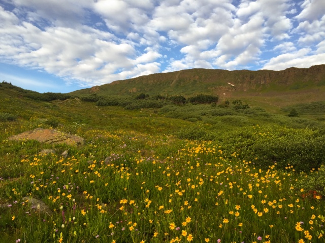
We again wore all our layers and climbed into the sunshine, peeling off the extra clothes when we reached the high point of the Colorado Trail (13,274 ft), also the high point of this summer's section of the CDT. (We reached the actual high point of the CDT, Gray's Peak at 14,261 ft, in the summer of 2014). Then we enjoyed meandering along the high alpine ridges, with incredible views of the San Juan Mountains, beautiful golden wildflowers. Shy pika chirped as we passed, then dashed out of sight. Bold marmots also chirped at us, but stood proudly on nearby rocks. A herd of bighorn sheep grazed in a meadow below. 

Throughout the day we met Nordic Track (PCT '15) and a handful of other hikers. But mostly we met Colorado Trail mountain bike racers, some looking strong, others looking wiped out even at the beginning of the day. All of them agreed that there was a lot more hiking than biking involved in the race, but what incredible terrain to hike a bike through!

We dropped down into the trees and then crossed the Jarosa Mesa, where a large herd of sheep were grazing.  Our pace quickened as we descended into the trees. We knew we were close. 

"Daddy!"  Sierra shrieked, as she started running down the trail. In the distance, a tall figure began running up to meet her. The two collided into a big hug. Then, together, we hiked the last mile down to Spring Creek Pass, where our CDT adventure started. 

Our CDT adventure over, it was time for celebration.  We reminisced a bit, compared starting and ending photos (wow, she's grown!), and waited for it all to sink in.  It took three summer vacations, but we finally did it!  We hiked the Continental Divide Trail!


Thursday, July 28, 2016

Day 44: Colorado Trail Junction to Abandoned Mine

The pale, glowing half moon lit the night sky. I shivered in my down cocoon, watching. Outside, a frost formed on the meadow. 

The sun reached our meadow as we packed up. Even so, we hiked out wearing all our warm clothes, toes still numb. But we still enjoyed the beauty as the first golden sunlight bathed the nearby mountains, which were reflected in a nearby pond. 

After the solitude of the New Mexico CDT, overlapping with the super popular Colorado Trail is a real adjustment.  Now the trail is clearly marked, willows neatly cut back from the trail. Numerous footprints of hikers and horses are imprinted into the hard dried mud. Giant rock cairns are visible from one ridge to the next over a mile away, like signal fires of old. The rock cairns suggest a high stakes Jenga game, as each rock precariously balanced on another to create a stable whole. 

And then there are the other hikers. Lots of hikers.  Men, women, young, old, human, canine. Even bikers, who seemed to spend a lot of time hiking, pushing their bikes up steep, rocky hills. Some hikers had towering packs that would give Cheryl Strayed's "Monster" a run for its money and others mimicked the fast and light style of ultralight long distance thru hikers. We were meeting hikers frequently now, due in part to the fact that we are hiking northbound on the CDT and most Colorado Trail hikers head southbound. By the end of the day, we would see more hikers than during all the rest of this summer's hike combined. 

"Baaaa!"  The protests of hundreds of sheep met our ears as we rounded a be d in the trail. An efficient sheep dog sprinted across the hillside, herding the sheep down to a grazed area near the shepherd's camp. 

We watched the clouds gather as we ate lunch by a small alpine lake (12,817 ft). All afternoon, the clouds threatened. We watched the rain on nearby ridges. Strong winds and a few spots of rain had us scurrying for our jackets only to remove them less than an hour later when the sun came out. 

More and more bikes came tearing down the trail (or slogging up the climbs). One rider, who had stopped to filter water at a creek), explained that they were part of a Colorado Trail bike race. Similar to the Tour Divide, riders are times using the tracking feature on a Spot device, which he had lashed to his bike frame. Headlamp strapped to his helmet, he planned to ride on to Silverton that night. 

Although we started passing the tents of camping Colorado Trail hikers by 3:00 in the afternoon, we hiked on. By early evening, we reached the final climb to the high point on the Colorado Trail (which is not the highest point on the CDT as the CDT climbs over 14,000 feet on the top of Gray's Peak farther north in Colorado) and a dilemma. If we continued, we would have to either camp above 13,000 feet or continue hiking in the dark for eight more miles to a safe camp.  With clouds still threatening, we chose to stop early, and found a flat, rocky camp at an old mining site. 


Wednesday, July 27, 2016

Day 43: La Vaca Creek to Colorado Trail Junction

I watched the first light as it slowly worked its way down the mountain. The warm light touched the meadow, melting the morning frost. But it could not reach our little camp, tucked away in the trees on the fringe of the meadow, and the morning was chilly. We lingered in our sleeping bags for warmth. 

When we finally started climbing up the trail, we met our first thru-hiker of the summer, Hippie Longstocking. She is at the back of the pack heading northbound, although she decided to flip and hike this section southbound to join friends. She has hiked all over, and we really enjoyed talking with her. 

We continued climbing to a small lake below The Window, a rectangular shaped notch in the rocky ridge. There we encountered a large group of young people, their REI dome tents plunked down right next to the trail, partially obscuring the view of the lake and nearby mountains. Most of the campers were just emerging from their tents, although it was late morning. One young man lumbered down to the stream and dunked his food encrusted metal fork and spoon in the water. He grunted an unintelligible response to our greeting as we passed. Most of the group just ignored us or talked about us as though we weren't there. "I think they're photographers," one boy asserted knowingly, as I attempted to take a photograph of the lake and The Window that did not include any the herd of people milling about or their large, colorful tents. 

The Window was incredible, as were the surrounding mountains. We enjoyed lunch on the rocky cliffs on the ridge, with spectacular views of the rugged mountains and the lush green meadows below. We spent the rest of the day meandering past gorgeous, flower-filled high alpine meadows and clear blue lakes.

And then we reached the junction of the CDT and the Colorado Trail. In some ways, this is the end of the journey. We already hiked the remaining 40 miles when we hiked the Colorado Trail in 2013. But we plan to finish our CDT journey where we started at Spring Creek Pass, so after a brief celebration, we continued up the trail. 

We camped high on the mesa, grateful for a clear night. Without a moon in the sky (it would rise later on the night), the sky looked like a planetarium, with unobstructed, 360 degree views of bright stars set against a dark sky.


Tuesday, July 26, 2016

Day 42: Trout Lake to Valley Above La Vaca Creek

A narrow sliver of sunlight pierced the dark grey veil of clouds that shrouded our little valley. The mountains came alive, basking in the light and warmth. The still pond near our camp reflected the soft glow of the mountains and the golden sunflowers that lined its shores. Nearby, elk called to one another as they grazed. 

We climbed back up to the CDT, and continued climbing to the ridge. We would climb high and stay high for much of the day, enjoying incredible views and fields of wildflowers on every ridge. 

The constant threat of thunderstorms changes how we view the landscape. We still appreciate the incredible beauty, but we are constantly scanning for terrain features that might shelter us from a storm, gauging how far it is to the nearest gully or small stand of trees. And we are frequently too hot, climbing ridges in layers of rain gear. 

We did not see any other hikers all day. Then, rounding a corner a pack train approached, with a solitary packer, a string of loaded animals, and a handful of clients experiencing the mountains by horseback. 

We finally descended from the alpine ridges, following the North Fork of Los Pinos River into a beautiful, lush, green valley. Deer grazed by the many branches of the river. Three backpackers greeted us on the other side, inviting us to join them at their camp in the trees if we did not find anything up the trail. We hiked on slowly, distracted by the wild strawberries that lined the trail. 

Reaching a higher valley with multiple campsites, we decided to make an early camp, knowing that campsites might be scarce as we continued to climb. The rain resumed shortly after we climbed into the tent. Through the rain I heard something large crunching near our tent. Two eyes reflected back at me when I peered outside with a headlamp. The deer stared back at me a moment, then returned to grazing loudly. 


Monday, July 25, 2016

Day 41: Mile 896 to Trout Lake

A lone marmot posed on a rock like a yogi, surveying the valley below
In his own version of the sun salutation pose. We caught only glimpses of the sun through a thin curtain of grey cloud, but magic happened when the sun touched the high alpine meadows. The sun brought color and life to the magenta paintbrush, golden sunflowers, lavender daisies, and other wildflowers that dotted the amber green grass. We reveled in the beauty. 

A solitary hiker crossed the meadow to meet us. He was finishing up a short section, and has been hiking small pieces of the CDT when he has time. We enjoyed talking with him. Even better, a few miles down the trail we discovered a bag of gummy Lifesavers he dropped. Thru-hikers at heart, we ate them!

Once again, the storms began like clockwork at 11:30. We huddled under a rock overhang flanked by two firs to eat our lunch. We were grateful when the rain finally stopped because the trail traverses a series of high exposed ridgelines. The trail is steep and rocky in places, and progress was slow. At times, I felt I was roller skating on marbles as I slipped on loose rocks. 

We planned to camp at Cherokee Lake, just before the Knife Edge. But there was no sheltered camping there and we decided to hike on. The rain started up again just as we reached the Knife Edge, named for its sheer cliffs above the trail and steep drop off below. Even with the rain, the Knife Edge was beautiful: rugged cliffs, great views, and a trail lined with wildflowers. And then we were treated to a double rainbow. Magic!

The CDT remains high and exposed for some time. So when we reached there junction with the the Williams Creek Trail, we took the short side hike to Trout Lake to camp. As we approached, we spotted two blue tents in the trees about a quarter mile from where we camped. Now, as we are getting ready to sleep, we hear the happy shouts of a family. Other than when we stayed at a car campground, such as Ghost Ranch, it is the first night we've camped near other people this summer. 


Sunday, July 24, 2016

Day 40: Wolf Creek Pass to Mile 896

The beginning of the end. Our final section to complete the CDT. 

We met several people within the first few miles: a pair of mountain bikers careening around a blind corner, two weekend backpackers, and a day hiker. And we heard young voices bellowing out the song BINGO at the top of their lungs. And then there was no one. Just the complete solitude we've come to expect on the CDT. 

If we were hoping for a sunny, dry section, we were soon to be disappointed.  The first thunderstorm began shortly after 11, starting with a few spots of rain and quickly escalating into a downpour. We huddled under a pair of scrawny fir trees for lunch, then trudged up the trail, slipping in mud and crunching on hail. 

The rain teased us all afternoon. We added and removed layers frequently as the rain stopped and started on fits and spurts. Thankfully, the thunder did not return with the rain, and we were able to safely navigate several beautiful miles high on the ridge. 

When the trail finally dipped below 12,000 feet, we decided to make an early camp. If we continued, we would have at least 7 more steep, high elevation miles before camp. Instead, we decided to call it a day and enjoy a relaxing evening. Unfortunately, camping was scarce. We finally selected a sandy spot just below the ridge. Although I was nervous because the camp was more exposed than I would like, most of the clouds cleared to expose a dark sky full of bright stars. 


Saturday, July 23, 2016

Day 39: Silver Pass to Wolf Creek Pass (South Fork Nearo)

Food. Showers. Even at the end of a section as beautiful as the southern San Juans, it is impossible to stave off the excitement of heading into town for real food, showers, and a fresh resupply. With only a handful of miles left to Wolf Creek Pass, we did not have long to wait. 

An abandoned red snow plow signaled that we had passed the Wolf Creek Ski Area boundary. Several groups of day hikers crowded their way to the ridge, most headed to see the view from nearby Mount Alberta. Although we admired the colorful flowers and the spectacular views, we were on a mission. 

Soon we were piled into a pickup truck, speeding toward the tiny town of South Fork. On the other side of the pass lay Pagosa Springs, a larger town with more services for hikers who might need them. But for us, the quiet, friendly town of South Fork worked just fine. 

Ramon's, the Mexican restaurant, provided excellent service and a delicious dinner. We topped it off with a pint of Ben & Jerry's ice cream, and settled in for a relaxing evening. 


Friday, July 22, 2016

Day 38: North Fork Conejo River to Silver Pass

There is one item that doesn't appear on anyone's CDT gear list, yet should be mandatory equipment: a machete. Even in a relatively popular wilderness area like South San Juan Wilderness, the trail is badly overgrown in places. We began our morning pushing through firs and willow that completely obscured the trail. As we focused on keeping the upper branches from stabbing our eyes or scratching our faces, the lower branches grasped our legs as effectively as Devil's Snare in Harry Potter and the Sorcerer's Stone.

After a month of dreaming about icy cold water while hiking in the desert, the southern San Juans are a dream come true. Rivers, creeks, and streams are everywhere. At one, water cascades over the rocks in a beautiful series of waterfalls, the upper falls forming icicles before passing by a melting snow bank, then continuing past the trail and into the valley below. At the Adams Fork of the Conejos, the water tumbles down the mountain into fields of wildflowers.  

Piles of thunderheads greeted us when we climbed onto the ridge. Our hearts sank. The trail would stay above 12,000 feet for more than 6 miles. Oh, Colorado. You lure us in with your lofty peaks, your lush green mountains, your colorful wildflowers, your herds of elk and wildlife, and your icy cold creeks. Then you try to kill us with your endless exposed ridges and your frequent thunderstorms. 

We met a wizened local backpacker high on the ridge. He studied the clouds, then sagely advised us to check the skies and evaluate heading for cover by mid afternoon.  But by mid afternoon we were already below treeline, and the clouds seems to have converged on a ridge some miles away. 

We hiked several sections of beautiful trail recently built or maintained by the Southwest Conservation Corp. Nearby, several rocky, narrow, off-camber sections of trail traversed steep ridges with dangerous drops.  Perhaps the next trail project?

As tempting as it was to head for town, Wolf Creek Pass, the next highway crossing that would take us to our final resupply in South Fork, was just too far away. We camped on a wooded saddle at Silver Pass, and dreamed of the delicious food we would eat the next day.